Introduction
Crude oil resources in the state were discovered and produced in the southern part of the Gulf Coastal Plain of south Arkansas, which includes the following ten counties: Ashley, Union, Ouachita, Columbia, Nevada, Hempstead, Bradley, Calhoun, Lafayette, and Miller. Historically, most of the oil production has been in Union, Lafayette, Columbia, and Ouachita counties. These four counties have been responsible for more than eighty-five percent of the oil produced in Arkansas.
History of Discovery and Exploration
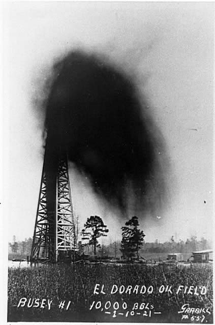
The first Arkansas well that yielded sufficient quantities of oil was the Hunter No. 1 that was drilled in April 16, 1920 near Stephens, in Ouachita County. A few days later, gas was discovered in the northern part of the present El Dorado field in Union County by the Constantin Oil and Refining Company. On January 10, 1921, oil was discovered in the S. T. Busey well (below) in the same field. The S.T. Busey well marked the beginning of commercial oil production in Arkansas. 1
See on the right - Historic photograph of the S.T. Busey well that marked the beginning of south Arkansas oil production in 1921. (Photo courtesy of the Arkansas Natural Resources Museum, Smackover, Arkansas).
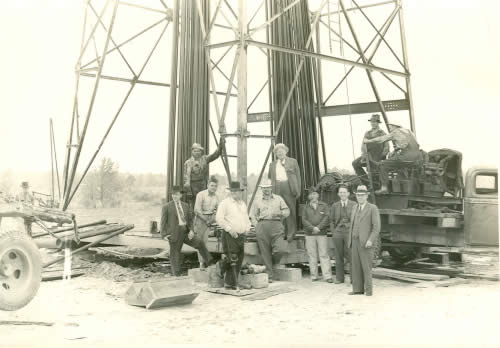
Historic photograph of the Smith-McClerkin No. 1 well drilled in Columbia County in 1941. (Photo courtesy of Arkansas Natural Resources Museum, Smackover, Arkansas).
Although most of crude oil was extracted from stripper wells that produced less than 10 barrels per day in the south Arkansas, Arkansas has two giant oil-producing fields. The Smackover field, discovered in 1922, produced 606,627,681 barrels of crude oil as of 2016. The Magnolia field, discovered in 1938, produced 173,099,821 barrels as of 2016.2
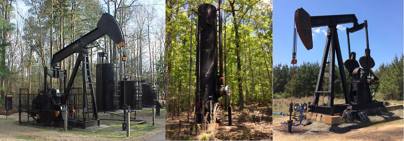
In south Arkansas, several wells have been drilled to depths exceeding 16,000 feet. An exploratory well in Hempstead County was drilled to 17,349 feet. Elsewhere, an exploratory well in Ashley County was drilled to a depth of 16,611 feet. There are several oil wells which produce from a depth exceeding 11,000 feet along the southern border of Arkansas in Lafayette County.
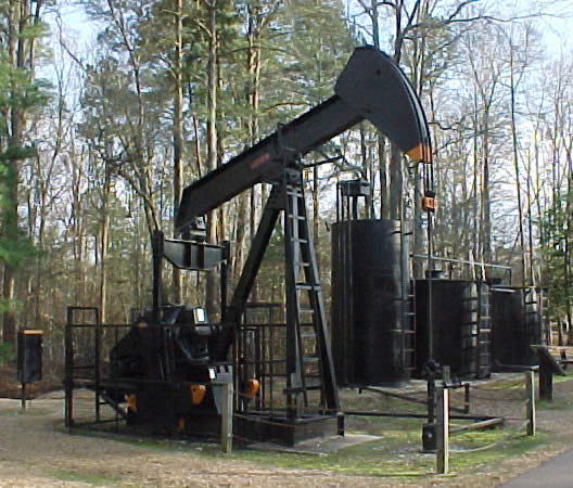
See on the left - Photograph of a modern oil well pumping unit and tank battery commonly used in south Arkansas oil fields. (Photo courtesy of Arkansas Natural Resources Museum, Smackover, Arkansas)
General Petroleum Geology
Upper Jurassic (Oxfordian) Smackover lime mudstones are the major source rock in south Arkansas. The reservoir rocks in this region are widely distributed in the sandstones and limestones of Cretaceous and Jurassic sections.
Production Data
From 1920 to 2016, 1,889,239,718 barrels of oil have been produced in Arkansas. Annual production data for 2016, which is compiled from 356 fields in south Arkansas, is 5,470,499 barrels of oil and 7,831,679 MCF of gas.2
The oil and condensate reserves as of January 1, 1998, are estimated to be 210,173,106 barrels while the gas reserves associated with the oil and condensate are estimated to be 511,659,605 MCF.3 The crude oil proved reserves (proved reserves is a technical term for how much we are reasonably sure is still in the ground, waiting to be extracted) in Arkansas are estimated to be about 51 million barrels in 2016.4
Yearly oil production in South Arkansas
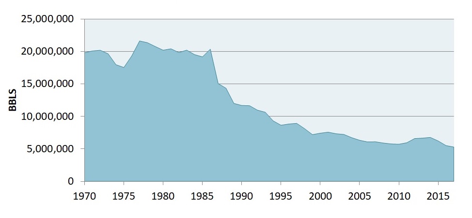
For oil production information, please click the link below to download the spreadsheet:
![]() Yearly oil production in South Arkansas
Yearly oil production in South Arkansas
![]() Major Oil Producing Formations In South Arkansas
Major Oil Producing Formations In South Arkansas
References
- Spooner, W.C., Oil and gas geology of the Gulf Coastal Plain in Arkansas, Arkansas Geological Survey Bulletin 2, 1935, p.140-141.
- Annual report of production, 2016, Arkansas Oil and Gas Commission.
- Annual oil and gas report, 1997, Arkansas Oil and Gas Commission.
- Energy Information Administration website http://tonto.eia.doe.gov/state/state_energy_profiles.cfm?sid=AR#
General Petroleum Geology
Petroleum geology is principally concerned with the evaluation of seven key elements in sedimentary basins: source, reservoir, seal, trap, timing, maturation, and migration.
Evaluation of the source uses the methods of geochemistry to quantify the nature of organic-rich rocks which contain the precursors to hydrocarbons, such that the type and quality of expelled hydrocarbon can be assessed.
The reservoir is a porous and permeable lithological unit or set of units that holds the hydrocarbon reserves. Analysis of reservoirs at the simplest level requires an assessment of their porosity (to calculate the volume of in situ hydrocarbons) and their permeability (to calculate how easily hydrocarbons will flow out of them). Some of the key disciplines used in reservoir analysis are the fields of stratigraphy, sedimentology, and reservoir engineering.
The seal, or cap rock, is a unit with low permeability that impedes the escape of hydrocarbons from the reservoir rock. Common seals include evaporites, chalks and shales. Analysis of seals involves assessment of their thickness and extent, such that their effectiveness can be quantified.
The trap is the stratigraphic or structural feature that ensures the juxtaposition of reservoir and seal such that hydrocarbons remain trapped in the subsurface, rather than escaping (due to their natural buoyancy) and being lost.
Analysis of maturation involves assessing the thermal history of the source rock in order to make predictions of the amount and timing of hydrocarbon generation and expulsion.
Finally, careful studies of migration reveal information on how hydrocarbons move from source to reservoir and help quantify the source of hydrocarbons in a particular area.
Subsurface Stratigraphic Chart of South Arkansas
Learn more about geologic time scale of South Arkansas
View printable Subsurface Stratigraphic Chart of South Arkansas »
Depositional History of Gulf Coastal Plain in South Arkansas
Sedimentation in the Gulf Coastal Plain in south Arkansas was associated with rifted continental margin tectonics resulting from the breakup of Pangea and the opening of the Gulf of Mexico. Triassic graben-filled red beds were deposited locally as the oldest Mesozoic strata above pre-rift Paelozoic basement during the early stages of extension and rifting.
