1:24,000 Scale Topographic Quadrangle Maps for Arkansas
| AGC/AGS Series | Arkansas Topographic Maps - 1:24,000 Scale - 7 1/2' Series |
| Number Series | |
| Title | 1:24,000 Scale Topographic Quadrangle Maps for Arkansas |
| Author (s) | U.S. Geological Survey |
| Date | Varies |
| Scale | 1:24,000 Scale (1 inch on map represents 2000 ft on ground) [Also known as 7 1/2' map series] |
| General Description |
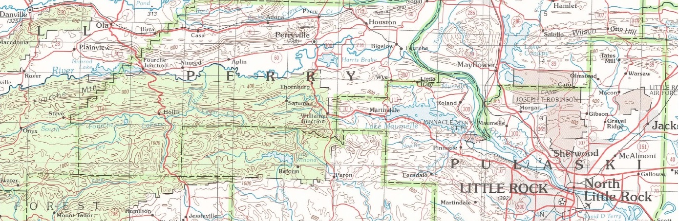
There are 916 individual 1:24,000 scale topographic maps that cover the State of Arkansas. See index below to locate individual map names. The contour interval lines range from 5' in eastern Arkansas to 20' in western and north-western Arkansas. These maps are very detailed and show township, range and sections for areas covered. (Download .pdf file below to view index for map names or request a copy from our office)
|
| Availability | Yes. Paper copy or free download. |
| Price |
Paper copy is $8.00 or download map for free. Effective April 1, 2019 the prices of the print on demand 1:24,000 Scale Topographic Quadrangle Maps for Arkansas is going up to $15.00. If requesting more than 5 copies it will take a additional time to fill request. |
| Shipping and handling | Contact Sales Office at (501) 296-1877, for shipping and handling charges. |
| Online Version |
Download Index PDF |
| Record |
916 individual 1:24,000 scale topographic maps from A to Z
Abbott Quadrangle ![]() (12.3 MB)
(12.3 MB)
Aberdeen Quadrangle ![]() (9.74 MB)
(9.74 MB)
Acorn Quadrangle ![]() (10.5 MB)
(10.5 MB)
Adona Quadrangle ![]() (11.7 MB)
(11.7 MB)
Agnos Quadrangle ![]() (9.52 MB)
(9.52 MB)
Alexander Quadrangle ![]() (16.1 MB)
(16.1 MB)
Alicia Quadrangle ![]() (7.32 MB)
(7.32 MB)
Alma Quadrangle ![]() (11.8 MB)
(11.8 MB)
Almyra Quadrangle ![]() (8.05 MB)
(8.05 MB)
Alpena Quadrangle ![]() (12.1 MB)
(12.1 MB)
Alread Quadrangle ![]() (12.2 MB)
(12.2 MB)
Altheimer Quadrangle ![]() (7.7 MB)
(7.7 MB)
Amagon Quadrangle ![]() (7.74 MB)
(7.74 MB)
Amity Quadrangle ![]() (13.7 MB)
(13.7 MB)
Antoine Quadrangle ![]() (9.15 MB)
(9.15 MB)
Aplin Quadrangle ![]() (12.7 MB)
(12.7 MB)
Arden Quadrangle ![]() (9.21 MB)
(9.21 MB)
Arkadelphia Quadrangle ![]() (9.13 MB)
(9.13 MB)
Arkansas City Quadrangle ![]() (9.87 MB)
(9.87 MB)
Arkansas Post Quadrangle ![]() (9.11 MB)
(9.11 MB)
Arkinda Quadrangle ![]() (9.08 MB)
(9.08 MB)
Armorel Quadrangle ![]() (8.18 MB)
(8.18 MB)
Artesian Quadrangle ![]() (8.34 MB)
(8.34 MB)
Ash Flat Quadrangle ![]() (10.5 MB)
(10.5 MB)
Ashdown East Quadrangle ![]() (8.55 MB)
(8.55 MB)
Ashdown West Quadrangle ![]() (8.43 MB)
(8.43 MB)
Athens Quadrangle ![]() (12.6 MB)
(12.6 MB)
Atkins Quadrangle ![]() (11.5 MB)
(11.5 MB)
Aubrey Quadrangle ![]() (7.58 MB)
(7.58 MB)
Augusta Quadrangle ![]() (8.46 MB)
(8.46 MB)
Augusta NE Quadrangle ![]() (9.16 MB)
(9.16 MB)
Augusta SW Quadrangle ![]() (10.6 MB)
(10.6 MB)
Auvergne Quadrangle ![]() (7.92 MB)
(7.92 MB)
Avant Quadrangle ![]() (12.3 MB)
(12.3 MB)
Avery Quadrangle ![]() (9.89 MB)
(9.89 MB)
Avon Quadrangle ![]() (10.9 MB)
(10.9 MB)
Baker Springs Quadrangle ![]() (12.2 MB)
(12.2 MB)
Bald Knob Quadrangle ![]() (10.2 MB)
(10.2 MB)
Banks Quadrangle ![]() (8.75 MB)
(8.75 MB)
Barber Quadrangle ![]() (10.9 MB)
(10.9 MB)
Barkman Quadrangle ![]() (9.04 MB)
(9.04 MB)
Barling Quadrangle ![]() (11.8 MB)
(11.8 MB)
Barney Quadrangle ![]() (9.89 MB)
(9.89 MB)
Batavia Quadrangle ![]() (12.2 MB)
(12.2 MB)
Bates Quadrangle ![]() (14.4 MB)
(14.4 MB)
Batesville Quadrangle ![]() (15.3 MB)
(15.3 MB)
Bearden Quadrangle ![]() (8.36 MB)
(8.36 MB)
Beaver Quadrangle ![]() (17.2 MB)
(17.2 MB)
Bee Branch Quadrangle ![]() (11.2 MB)
(11.2 MB)
Bee Mountain Quadrangle ![]() (12.2 MB)
(12.2 MB)
Beebe Quadrangle ![]() (10.8 MB)
(10.8 MB)
Beedeville Quadrangle ![]() (7.54 MB)
(7.54 MB)
Belfast Quadrangle ![]() (11.9 MB)
(11.9 MB)
Ben Lomond Quadrangle ![]() (11.3 MB)
(11.3 MB)
Benoit Quadrangle ![]() (10.2 MB)
(10.2 MB)
Benton Quadrangle ![]() (13.5 MB)
(13.5 MB)
Bentonville North Quadrangle ![]() (14.6 MB)
(14.6 MB)
Bentonville South Quadrangle ![]() (11.4 MB)
(11.4 MB)
Bergman Quadrangle ![]() (15.3 MB)
(15.3 MB)
Berlin Quadrangle ![]() (8.16 MB)
(8.16 MB)
Berryville Quadrangle ![]() (13.6 MB)
(13.6 MB)
Bethesda Quadrangle ![]() (12.7 MB)
(12.7 MB)
Beulah Quadrangle ![]() (8.43 MB)
(8.43 MB)
Bidville Quadrangle ![]() (12.6 MB)
(12.6 MB)
Big Flat Quadrangle ![]() (12.7 MB)
(12.7 MB)
Big Fork Quadrangle ![]() (15.4 MB)
(15.4 MB)
Bismarck Quadrangle ![]() (15.1 MB)
(15.1 MB)
Black Rock Quadrangle ![]() (7.72 MB)
(7.72 MB)
Blevins Quadrangle ![]() (11 MB)
(11 MB)
Bloomburg Quadrangle ![]() (9.99 MB)
(9.99 MB)
Blue Eye Quadrangle ![]() (11.5 MB)
(11.5 MB)
Blue Mountain Quadrangle ![]() (10 MB)
(10 MB)
Blue Mountain Dam Quadrangle ![]() (15.4 MB)
(15.4 MB)
Bluff City Quadrangle ![]() (8.64 MB)
(8.64 MB)
BLUFFTON Quadrangle ![]() (12.2 MB)
(12.2 MB)
Blytheville Quadrangle ![]() (8.61 MB)
(8.61 MB)
Board Camp Quadrangle ![]() (8.34 MB)
(8.34 MB)
Bodcaw Quadrangle ![]() (7.48 MB)
(7.48 MB)
Bog Springs Quadrangle ![]() (11.7 MB)
(11.7 MB)
Boles Quadrangle ![]() (10.3 MB)
(10.3 MB)
Bonnerdale Quadrangle ![]() (12.4 MB)
(12.4 MB)
Bono Quadrangle ![]() (7.94 MB)
(7.94 MB)
Booneville Quadrangle ![]() (9.79 MB)
(9.79 MB)
Boston Quadrangle ![]() (10.5 MB)
(10.5 MB)
Boswell Quadrangle ![]() (13.9 MB)
(13.9 MB)
Botkinburg Quadrangle ![]() (11.6 MB)
(11.6 MB)
Boxley Quadrangle ![]() (16.4 MB)
(16.4 MB)
Boyd Hill Quadrangle ![]() (11.4 MB)
(11.4 MB)
Boydsville Quadrangle ![]() (11.2 MB)
(11.2 MB)
Bradford Quadrangle ![]() (10.8 MB)
(10.8 MB)
Bradley Quadrangle ![]() (8.44 MB)
(8.44 MB)
Bradley NE Quadrangle ![]() (8.14 MB)
(8.14 MB)
Bradley SE Quadrangle ![]() (9.94 MB)
(9.94 MB)
Bragg City Quadrangle ![]() (12.8 MB)
(12.8 MB)
Branch Quadrangle ![]() (10.1 MB)
(10.1 MB)
Brentwood Quadrangle ![]() (11.2 MB)
(11.2 MB)
Brickeys Quadrangle ![]() (10.8 MB)
(10.8 MB)
Brinkley Quadrangle ![]() (8.53 MB)
(8.53 MB)
Brookland Quadrangle ![]() (10.5 MB)
(10.5 MB)
Brownsville Quadrangle ![]() (10.2 MB)
(10.2 MB)
Bruno Quadrangle ![]() (10.8 MB)
(10.8 MB)
Brushy Creek Mountain Quadrangle ![]() (12.6 MB)
(12.6 MB)
Bryant Quadrangle ![]() (12.2 MB)
(12.2 MB)
Buck Knob Quadrangle ![]() (14.5 MB)
(14.5 MB)
Buckner Quadrangle ![]() (9.61 MB)
(9.61 MB)
Buena Vista Quadrangle ![]() (9.55 MB)
(9.55 MB)
Buffalo City Quadrangle ![]() (12.6 MB)
(12.6 MB)
Bull Shoals Quadrangle ![]() (13.9 MB)
(13.9 MB)
Bunn Quadrangle ![]() (8.9 MB)
(8.9 MB)
Burnville Quadrangle ![]() (10.3 MB)
(10.3 MB)
Bussey Quadrangle ![]() (7.86 MB)
(7.86 MB)
Byron Quadrangle ![]() (10.7 MB)
(10.7 MB)
Cabot Quadrangle ![]() (11.4 MB)
(11.4 MB)
Caddo Gap Quadrangle ![]() (12.8 MB)
(12.8 MB)
Caddo Valley Quadrangle ![]() (12.6 MB)
(12.6 MB)
Cades Quadrangle ![]() (9.21 MB)
(9.21 MB)
Calhoun Quadrangle ![]() (8.91 MB)
(8.91 MB)
Calico Rock Quadrangle ![]() (15.5 MB)
(15.5 MB)
Calion Quadrangle ![]() (9.99 MB)
(9.99 MB)
Calmer Quadrangle ![]() (9.06 MB)
(9.06 MB)
Camden Quadrangle ![]() (12.4 MB)
(12.4 MB)
Camden SW Quadrangle ![]() (12.1 MB)
(12.1 MB)
Camp Quadrangle ![]() (8.96 MB)
(8.96 MB)
Campbell Quadrangle ![]() (8.51 MB)
(8.51 MB)
Canaan Quadrangle ![]() (13.3 MB)
(13.3 MB)
Cane Creek Quadrangle ![]() (10.3 MB)
(10.3 MB)
Canfield Quadrangle ![]() (7.98 MB)
(7.98 MB)
Caraway Quadrangle ![]() (7.37 MB)
(7.37 MB)
Caldwell Quadrangle ![]() (7.87 MB)
(7.87 MB)
Carlisle Quadrangle ![]() (8.79 MB)
(8.79 MB)
Carthage Quadrangle ![]() (9.66 MB)
(9.66 MB)
Casa Quadrangle ![]() (10.3 MB)
(10.3 MB)
Cash Quadrangle ![]() (7.26 MB)
(7.26 MB)
Cass Quadrangle ![]() (11.4 MB)
(11.4 MB)
Catfish Point Quadrangle ![]() (10.7 MB)
(10.7 MB)
Cato Quadrangle ![]() (13 MB)
(13 MB)
Caulksville Quadrangle ![]() (10.1 MB)
(10.1 MB)
Cauthron Quadrangle ![]() (15.2 MB)
(15.2 MB)
Cave City Quadrangle ![]() (11.3 MB)
(11.3 MB)
Cecil Quadrangle ![]() (11.2 MB)
(11.2 MB)
Center Point Quadrangle ![]() (9.06 MB)
(9.06 MB)
Center Point NE Quadrangle ![]() (11.1 MB)
(11.1 MB)
Centerton Quadrangle ![]() (11.5 MB)
(11.5 MB)
Central Quadrangle ![]() (8.2 MB)
(8.2 MB)
Cerrogordo Quadrangle ![]() (8.76 MB)
(8.76 MB)
Chalybeate Mountain East Quadrangle ![]() (8.74 MB)
(8.74 MB)
Chalybeate Mountain West Quadrangle ![]() (9.6 MB)
(9.6 MB)
Chambersville Quadrangle ![]() (9.21 MB)
(9.21 MB)
Chapel Hill Quadrangle ![]() (8.71 MB)
(8.71 MB)
Charleston Quadrangle ![]() (10.2 MB)
(10.2 MB)
Charlotte Quadrangle ![]() (11.9 MB)
(11.9 MB)
Chatfield Quadrangle ![]() (8.29 MB)
(8.29 MB)
Cherokee City Quadrangle ![]() (9.83 MB)
(9.83 MB)
Cherry Valley East Quadrangle ![]() (12.6 MB)
(12.6 MB)
Cherry Valley West Quadrangle ![]() (7.21 MB)
(7.21 MB)
Chic Quadrangle ![]() (11.5 MB)
(11.5 MB)
Chickalah Mountain East Quadrangle ![]() (12.3 MB)
(12.3 MB)
Chickalah Mountain West Quadrangle ![]() (11.5 MB)
(11.5 MB)
Chidester Quadrangle ![]() (9.72 MB)
(9.72 MB)
Chula Mountain Quadrangle ![]() (13 MB)
(13 MB)
Clarendon Quadrangle ![]() (9.13 MB)
(9.13 MB)
Clarkridge Quadrangle ![]() (13 MB)
(13 MB)
Clarksville Quadrangle ![]() (12.2 MB)
(12.2 MB)
Cleveland Quadrangle ![]() (11 MB)
(11 MB)
Clinton Quadrangle ![]() (12.3 MB)
(12.3 MB)
Coal Hill Quadrangle ![]() (10.4 MB)
(10.4 MB)
Colcord NE Quadrangle ![]() (9.13 MB)
(9.13 MB)
Collins Quadrangle ![]() (8.07 MB)
(8.07 MB)
Collins NW Quadrangle ![]() (7.12 MB)
(7.12 MB)
Columbus Quadrangle ![]() (10.7 MB)
(10.7 MB)
Cominto Quadrangle ![]() (7.51 MB)
(7.51 MB)
Concord Quadrangle ![]() (10.6 MB)
(10.6 MB)
Congo Quadrangle ![]() (11.3 MB)
(11.3 MB)
Conway Quadrangle ![]() (14.1 MB)
(14.1 MB)
Cord Quadrangle ![]() (8.67 MB)
(8.67 MB)
Cornerstone Quadrangle ![]() (8.18 MB)
(8.18 MB)
Cornerville Quadrangle ![]() (698 KB)
(698 KB)
Corning Quadrangle ![]() (7.89 MB)
(7.89 MB)
Cotter Quadrangle ![]() (12.7 MB)
(12.7 MB)
Cotter NW Quadrangle ![]() (16.3 MB)
(16.3 MB)
Cotter SW Quadrangle ![]() (13.8 MB)
(13.8 MB)
Cotton Plant Quadrangle ![]() (8.27 MB)
(8.27 MB)
Cottonwood Point Quadrangle ![]() (9.73 MB)
(9.73 MB)
Council Quadrangle ![]() (11.3 MB)
(11.3 MB)
Cove Quadrangle ![]() (11 MB)
(11 MB)
Cozahome Quadrangle ![]() (13.7 MB)
(13.7 MB)
Cravens Quadrangle ![]() (10.2 MB)
(10.2 MB)
Crawfordsville Quadrangle ![]() (7.56 MB)
(7.56 MB)
Crocketts Bluff Quadrangle ![]() (10.2 MB)
(10.2 MB)
Crossett North Quadrangle ![]() (8.03 MB)
(8.03 MB)
Crossett South Quadrangle ![]() (8.8 MB)
(8.8 MB)
Crystal Springs Quadrangle ![]() (12.4 MB)
(12.4 MB)
Culler Quadrangle ![]() (8.43 MB)
(8.43 MB)
Curtis Quadrangle ![]() (8.55 MB)
(8.55 MB)
Dalark Quadrangle ![]() (9.37 MB)
(9.37 MB)
Dalton Quadrangle ![]() (10.1 MB)
(10.1 MB)
Damascus Quadrangle ![]() (11.3 MB)
(11.3 MB)
Daniels Chapel Quadrangle ![]() (8.69 MB)
(8.69 MB)
Dansby Quadrangle ![]() (11.8 MB)
(11.8 MB)
Danville Quadrangle ![]() (9.91 MB)
(9.91 MB)
Danville Mountain Quadrangle ![]() (10 MB)
(10 MB)
Dardanelle Quadrangle ![]() (12.6 MB)
(12.6 MB)
Datto Quadrangle ![]() (7.29 MB)
(7.29 MB)
De Gray Quadrangle ![]() (10.3 MB)
(10.3 MB)
De Queen Quadrangle ![]() (10.7 MB)
(10.7 MB)
De Queen NW Quadrangle ![]() (11.2 MB)
(11.2 MB)
De Roche Quadrangle ![]() (12.7 MB)
(12.7 MB)
De Valls Bluff Quadrangle ![]() (11.3 MB)
(11.3 MB)
De Valls Bluff NE Quadrangle ![]() (8.9 MB)
(8.9 MB)
De Valls Bluff SE Quadrangle ![]() (8.97 MB)
(8.97 MB)
DeWitt Quadrangle ![]() (9.67 MB)
(9.67 MB)
DeWitt NE Quadrangle ![]() (8.93 MB)
(8.93 MB)
DeWitt SW Quadrangle ![]() (7.54 MB)
(7.54 MB)
Deer Quadrangle ![]() (10.4 MB)
(10.4 MB)
Delaney Quadrangle ![]() (11.9 MB)
(11.9 MB)
Delaplaine Quadrangle ![]() (8.26 MB)
(8.26 MB)
Delaware Quadrangle ![]() (12.5 MB)
(12.5 MB)
Delight Quadrangle ![]() (9.16 MB)
(9.16 MB)
Dell Quadrangle ![]() (7.97 MB)
(7.97 MB)
Denver Quadrangle ![]() (11.8 MB)
(11.8 MB)
Des Arc East Quadrangle ![]() (9.86 MB)
(9.86 MB)
Des Arc West Quadrangle ![]() (9.29 MB)
(9.29 MB)
Diamond City Quadrangle ![]() (12.2 MB)
(12.2 MB)
Dierks Quadrangle ![]() (11.6 MB)
(11.6 MB)
Dierks Dam Quadrangle ![]() (11.4 MB)
(11.4 MB)
Dixie Quadrangle ![]() (7.98 MB)
(7.98 MB)
Doddridge Quadrangle ![]() (13.6 MB)
(13.6 MB)
Doddridge NE Quadrangle ![]() (8.05 MB)
(8.05 MB)
Doddridge NW Quadrangle ![]() (9.05 MB)
(9.05 MB)
Doddridge SE Quadrangle ![]() (9.17 MB)
(9.17 MB)
Domino Quadrangle ![]() (12 MB)
(12 MB)
Donaldson Quadrangle ![]() (11.3 MB)
(11.3 MB)
Dover Quadrangle ![]() (12.5 MB)
(12.5 MB)
Drasco Quadrangle ![]() (10.1 MB)
(10.1 MB)
Dumas Quadrangle ![]() (7.18 MB)
(7.18 MB)
Durham Quadrangle ![]() (9.13 MB)
(9.13 MB)
Eagle Mills Quadrangle ![]() (9.46 MB)
(9.46 MB)
Eagle Mountain Quadrangle ![]() (15.5 MB)
(15.5 MB)
Earle Quadrangle ![]() (9.47 MB)
(9.47 MB)
East Camden Quadrangle ![]() (8.41 MB)
(8.41 MB)
Eaton Quadrangle ![]() (9.83 MB)
(9.83 MB)
Edmondson Quadrangle ![]() (8.28 MB)
(8.28 MB)
El Dorado East Quadrangle ![]() (9.37 MB)
(9.37 MB)
El Dorado West Quadrangle ![]() (11.9 MB)
(11.9 MB)
Elaine Quadrangle ![]() (8.11 MB)
(8.11 MB)
Elizabeth Quadrangle ![]() (11.2 MB)
(11.2 MB)
Elkins Quadrangle ![]() (12.7 MB)
(12.7 MB)
Emerson Quadrangle ![]() (8.06 MB)
(8.06 MB)
Emerson SE Quadrangle ![]() (9.94 MB)
(9.94 MB)
Eminence Quadrangle ![]() (7.84 MB)
(7.84 MB)
Emmet Quadrangle ![]() (8.52 MB)
(8.52 MB)
Empire Quadrangle ![]() (7.52 MB)
(7.52 MB)
England Quadrangle ![]() (7.63 MB)
(7.63 MB)
Enola Quadrangle ![]() (9.7 MB)
(9.7 MB)
Ethel Quadrangle ![]() (10.3 MB)
(10.3 MB)
Etowah Quadrangle ![]() (8.54 MB)
(8.54 MB)
Eudora North Quadrangle ![]() (8.58 MB)
(8.58 MB)
Eudora NW Quadrangle ![]() (7.25 MB)
(7.25 MB)
Eudora South Quadrangle ![]() (8.96 MB)
(8.96 MB)
Eula Quadrangle ![]() (13.4 MB)
(13.4 MB)
Eureka Springs Quadrangle ![]() (13.5 MB)
(13.5 MB)
Evansville Quadrangle ![]() (11.7 MB)
(11.7 MB)
Evening Shade Quadrangle ![]() (9.49 MB)
(9.49 MB)
Everton Quadrangle ![]() (12.1 MB)
(12.1 MB)
Fair Oaks Quadrangle ![]() (7.26 MB)
(7.26 MB)
Fairfield Bay Quadrangle ![]() (12.3 MB)
(12.3 MB)
Faith Quadrangle ![]() (9.04 MB)
(9.04 MB)
Falcon Quadrangle ![]() (9.45 MB)
(9.45 MB)
Falls Chapel Quadrangle ![]() (9.67 MB)
(9.67 MB)
Fallsville Quadrangle ![]() (11.5 MB)
(11.5 MB)
Fannie Quadrangle ![]() (11.9 MB)
(11.9 MB)
Farmville Quadrangle ![]() (9.64 MB)
(9.64 MB)
Fayetteville Quadrangle ![]() (13.7 MB)
(13.7 MB)
Felsenthal Dam Quadrangle ![]() (9.78 MB)
(9.78 MB)
Fern Quadrangle ![]() (15.9 MB)
(15.9 MB)
Ferndale Quadrangle ![]() (14.5 MB)
(14.5 MB)
Fifty-Six Quadrangle ![]() (17 MB)
(17 MB)
Fletcher Lake Quadrangle ![]() (11.8 MB)
(11.8 MB)
Floral Quadrangle ![]() (10 MB)
(10 MB)
Floyd Quadrangle ![]() (11.3 MB)
(11.3 MB)
Fordyce Quadrangle ![]() (11.2 MB)
(11.2 MB)
Fordyce NE Quadrangle ![]() (9.2 MB)
(9.2 MB)
Foreman Quadrangle ![]() (9.31 MB)
(9.31 MB)
Formosa Quadrangle ![]() (11.6 MB)
(11.6 MB)
Forrest City Quadrangle ![]() (10.6 MB)
(10.6 MB)
Fort Douglas Quadrangle ![]() (11.5 MB)
(11.5 MB)
Fort Smith Quadrangle ![]() (16 MB)
(16 MB)
Forum Quadrangle ![]() (14.8 MB)
(14.8 MB)
Fouke Quadrangle ![]() (10.3 MB)
(10.3 MB)
Fouke NE Quadrangle ![]() (8.27 MB)
(8.27 MB)
Fouke SE Quadrangle ![]() (9.91 MB)
(9.91 MB)
Fountain Hill Quadrangle ![]() (8.31 MB)
(8.31 MB)
Fountain Lake Quadrangle ![]() (15.5 MB)
(15.5 MB)
Fourche Quadrangle ![]() (12.6 MB)
(12.6 MB)
Fourche SW Quadrangle ![]() (15.5 MB)
(15.5 MB)
Fox Quadrangle ![]() (12.5 MB)
(12.5 MB)
Franklin Quadrangle ![]() (12.2 MB)
(12.2 MB)
Freedom Mountain Quadrangle ![]() (14.2 MB)
(14.2 MB)
Frenchmans Bayou Quadrangle ![]() (10.1 MB)
(10.1 MB)
Friars Point Quadrangle ![]() (9.92 MB)
(9.92 MB)
Friars Point NW Quadrangle ![]() (9.06 MB)
(9.06 MB)
Fulton Quadrangle ![]() (10.2 MB)
(10.2 MB)
Gaither Quadrangle ![]() (13.6 MB)
(13.6 MB)
Gallatin Quadrangle ![]() (13 MB)
(13 MB)
Gamaliel Quadrangle ![]() (11.1 MB)
(11.1 MB)
Gardner Quadrangle ![]() (9.96 MB)
(9.96 MB)
Garfield Quadrangle ![]() (14 MB)
(14 MB)
Garland Quadrangle ![]() (9 MB)
(9 MB)
Garner Quadrangle ![]() (11.3 MB)
(11.3 MB)
Garrett Grove Quadrangle ![]() (8.4 MB)
(8.4 MB)
Geneva Quadrangle ![]() (12.8 MB)
(12.8 MB)
Gentry Quadrangle ![]() (13.1 MB)
(13.1 MB)
Georgetown Quadrangle ![]() (10.1 MB)
(10.1 MB)
Gepp Quadrangle ![]() (11.7 MB)
(11.7 MB)
Geridge Quadrangle ![]() (9.12 MB)
(9.12 MB)
Gethsemane Quadrangle ![]() (7.77 MB)
(7.77 MB)
Gieseck Quadrangle ![]() (7.81 MB)
(7.81 MB)
Gillett Quadrangle ![]() (9.82 MB)
(9.82 MB)
Gillham Quadrangle ![]() (12.9 MB)
(12.9 MB)
Gillham Dam Quadrangle ![]() (13.4 MB)
(13.4 MB)
Gleason Quadrangle ![]() (12 MB)
(12 MB)
Glen Allan Quadrangle ![]() (9.41 MB)
(9.41 MB)
Glendale Quadrangle ![]() (8.67 MB)
(8.67 MB)
Glenwood Quadrangle ![]() (12.2 MB)
(12.2 MB)
Golddust Quadrangle ![]() (10.1 MB)
(10.1 MB)
Golden City Quadrangle ![]() (13.1 MB)
(13.1 MB)
Goosepond Mountain Quadrangle ![]() (14.3 MB)
(14.3 MB)
Goshen Quadrangle ![]() (10.8 MB)
(10.8 MB)
Gould Quadrangle ![]() (7.27 MB)
(7.27 MB)
Gourd Quadrangle ![]() (8.7 MB)
(8.7 MB)
Grady Quadrangle ![]() (7.73 MB)
(7.73 MB)
Grandview Quadrangle ![]() (10.8 MB)
(10.8 MB)
Grange Quadrangle ![]() (10.6 MB)
(10.6 MB)
Grapevine Quadrangle ![]() (12 MB)
(12 MB)
Gravelly Quadrangle ![]() (13.4 MB)
(13.4 MB)
Gravette Quadrangle ![]() (14.2 MB)
(14.2 MB)
Grays Quadrangle ![]() (8.09 MB)
(8.09 MB)
Green Forest Quadrangle ![]() (12.9 MB)
(12.9 MB)
Greenbrier Quadrangle ![]() (11.8 MB)
(11.8 MB)
Greenfield Quadrangle ![]() (10 MB)
(10 MB)
Greenville Quadrangle ![]() (13.9 MB)
(13.9 MB)
Greenway Quadrangle ![]() (8.56 MB)
(8.56 MB)
Greenwood Quadrangle ![]() (11 MB)
(11 MB)
Greers Ferry Quadrangle ![]() (16.1 MB)
(16.1 MB)
Greers Ferry Dam Quadrangle ![]() (12.9 MB)
(12.9 MB)
Gregory Quadrangle ![]() (8.83 MB)
(8.83 MB)
Gregory SW Quadrangle ![]() (9.11 MB)
(9.11 MB)
Grubbs Quadrangle ![]() (8.13 MB)
(8.13 MB)
Guion Quadrangle ![]() (15.4 MB)
(15.4 MB)
Gunnison Quadrangle ![]() (10.2 MB)
(10.2 MB)
Gurdon Quadrangle ![]() (10.2 MB)
(10.2 MB)
Guy Quadrangle ![]() (10.6 MB)
(10.6 MB)
Hackett Quadrangle ![]() (11.9 MB)
(11.9 MB)
Hagarville Quadrangle ![]() (10.1 MB)
(10.1 MB)
Half Moon Quadrangle ![]() (532 KB)
(532 KB)
Halley Quadrangle ![]() (7.66 MB)
(7.66 MB)
Hamburg Quadrangle ![]() (8.06 MB)
(8.06 MB)
Hamilton Quadrangle ![]() (11.9 MB)
(11.9 MB)
Hamlet Quadrangle ![]() (12.6 MB)
(12.6 MB)
Hamlin Quadrangle ![]() (8.51 MB)
(8.51 MB)
Hampton Quadrangle ![]() (10 MB)
(10 MB)
Hardin Quadrangle ![]() (12.5 MB)
(12.5 MB)
Hardy Quadrangle ![]() (11.5 MB)
(11.5 MB)
Hardy NE Quadrangle ![]() (9.54 MB)
(9.54 MB)
Harmony Quadrangle ![]() (11 MB)
(11 MB)
Harmony Grove Quadrangle ![]() (9.61 MB)
(9.61 MB)
Harrell Brake Quadrangle ![]() (8.41 MB)
(8.41 MB)
Harriet Quadrangle ![]() (12.8 MB)
(12.8 MB)
Harrisburg Quadrangle ![]() (12.1 MB)
(12.1 MB)
Harrison Quadrangle ![]() (10.4 MB)
(10.4 MB)
Hartford Quadrangle ![]() (11.5 MB)
(11.5 MB)
Hartman Quadrangle ![]() (11.7 MB)
(11.7 MB)
Hartwell Quadrangle ![]() (10.8 MB)
(10.8 MB)
Harvey Quadrangle ![]() (12.8 MB)
(12.8 MB)
Haskell Quadrangle ![]() (11.8 MB)
(11.8 MB)
Hasty Quadrangle ![]() (15.8 MB)
(15.8 MB)
Hatchie Coon Quadrangle ![]() (8.54 MB)
(8.54 MB)
Hattieville Quadrangle ![]() (11.2 MB)
(11.2 MB)
Havana Quadrangle ![]() (10.8 MB)
(10.8 MB)
Hawkins Quadrangle ![]() (8.72 MB)
(8.72 MB)
Haynes Quadrangle ![]() (9.61 MB)
(9.61 MB)
Hazen Quadrangle ![]() (10.4 MB)
(10.4 MB)
Heafer Quadrangle ![]() (10.6 MB)
(10.6 MB)
Heber Springs Quadrangle ![]() (12.3 MB)
(12.3 MB)
Hector Quadrangle ![]() (12.2 MB)
(12.2 MB)
Helena Quadrangle ![]() (12.6 MB)
(12.6 MB)
Hempwallace Quadrangle ![]() (9.87 MB)
(9.87 MB)
Henrico NE Quadrangle ![]() (10.3 MB)
(10.3 MB)
Henrico SW Quadrangle ![]() (8.92 MB)
(8.92 MB)
Herbine Quadrangle ![]() (8.89 MB)
(8.89 MB)
Herman Quadrangle ![]() (8.26 MB)
(8.26 MB)
Hermitage Quadrangle ![]() (9.88 MB)
(9.88 MB)
Hickory Plains Quadrangle ![]() (10.2 MB)
(10.2 MB)
Hickory Ridge Quadrangle ![]() (7.14 MB)
(7.14 MB)
Hindsville Quadrangle ![]() (10.6 MB)
(10.6 MB)
Hiwasse Quadrangle ![]() (13.8 MB)
(13.8 MB)
Holla Bend Quadrangle ![]() (11 MB)
(11 MB)
Holland Quadrangle ![]() (12.1 MB)
(12.1 MB)
Holly Grove Quadrangle ![]() (8.48 MB)
(8.48 MB)
Holly Springs Quadrangle ![]() (10.5 MB)
(10.5 MB)
Hollywood Quadrangle ![]() (11.9 MB)
(11.9 MB)
Homan Quadrangle ![]() (8.59 MB)
(8.59 MB)
Hon Quadrangle ![]() (11.4 MB)
(11.4 MB)
Hope Quadrangle ![]() (9.96 MB)
(9.96 MB)
Hopeville Quadrangle ![]() (9.63 MB)
(9.63 MB)
Horatio Quadrangle ![]() (10.4 MB)
(10.4 MB)
Horseshoe Lake Quadrangle ![]() (12.7 MB)
(12.7 MB)
Horseshoe Mountain Quadrangle ![]() (11.4 MB)
(11.4 MB)
Hot Springs North Quadrangle ![]() (15.8 MB)
(15.8 MB)
Hot Springs South Quadrangle ![]() (14.4 MB)
(14.4 MB)
Houston Quadrangle ![]() (11.8 MB)
(11.8 MB)
Huff Quadrangle ![]() (10.2 MB)
(10.2 MB)
Hughes Quadrangle ![]() (10.2 MB)
(10.2 MB)
Humnoke Quadrangle ![]() (7.72 MB)
(7.72 MB)
Humphrey Quadrangle ![]() (10.8 MB)
(10.8 MB)
Humphrey SW Quadrangle ![]() (9.81 MB)
(9.81 MB)
Hunt Quadrangle ![]() (11.4 MB)
(11.4 MB)
Hunter East Quadrangle ![]() (7.9 MB)
(7.9 MB)
Hunter West Quadrangle ![]() (8.02 MB)
(8.02 MB)
Huntington Quadrangle ![]() (13.1 MB)
(13.1 MB)
Huntsville Quadrangle ![]() (13.7 MB)
(13.7 MB)
Huttig Quadrangle ![]() (9.5 MB)
(9.5 MB)
Imboden Quadrangle ![]() (12.5 MB)
(12.5 MB)
Indian Bay SE Quadrangle ![]() (10 MB)
(10 MB)
Ione Quadrangle ![]() (12.2 MB)
(12.2 MB)
Ivan Quadrangle ![]() (9.51 MB)
(9.51 MB)
Jacksonport Quadrangle ![]() (8.88 MB)
(8.88 MB)
Jacksonville Quadrangle ![]() (10 MB)
(10 MB)
Jamestown Quadrangle ![]() (9.15 MB)
(9.15 MB)
Japton Quadrangle ![]() (9.6 MB)
(9.6 MB)
Jasmine Quadrangle ![]() (8.73 MB)
(8.73 MB)
Jasper Quadrangle ![]() (16.4 MB)
(16.4 MB)
Jeanette Quadrangle ![]() (7.8 MB)
(7.8 MB)
Jericho Quadrangle ![]() (10.1 MB)
(10.1 MB)
Jerome Quadrangle ![]() (7.95 MB)
(7.95 MB)
Jersey Quadrangle ![]() (8.18 MB)
(8.18 MB)
Jerusalem Quadrangle ![]() (12.5 MB)
(12.5 MB)
Jessieville Quadrangle ![]() (11 MB)
(11 MB)
Joiner Quadrangle ![]() (8.59 MB)
(8.59 MB)
Jonesboro Quadrangle ![]() (12.5 MB)
(12.5 MB)
Joyland Quadrangle ![]() (8.46 MB)
(8.46 MB)
Judsonia Quadrangle ![]() (13.1 MB)
(13.1 MB)
Junction City Quadrangle ![]() (11.6 MB)
(11.6 MB)
Kedron Quadrangle ![]() (9.38 MB)
(9.38 MB)
Keevil Quadrangle ![]() (7.6 MB)
(7.6 MB)
Keiser Quadrangle ![]() (8.09 MB)
(8.09 MB)
Kelso Quadrangle ![]() (7.62 MB)
(7.62 MB)
Kennett North Quadrangle ![]() (8.81 MB)
(8.81 MB)
Kennett Quadrangle ![]() (9.25 MB)
(9.25 MB)
Keo Quadrangle ![]() (9.12 MB)
(9.12 MB)
Kingsland Quadrangle ![]() (9.88 MB)
(9.88 MB)
Kingston Quadrangle ![]() (10.6 MB)
(10.6 MB)
Knobel Quadrangle ![]() (7.71 MB)
(7.71 MB)
Knoxville Quadrangle ![]() (12 MB)
(12 MB)
Lagrange Quadrangle ![]() (12.8 MB)
(12.8 MB)
Laconia Quadrangle ![]() (10.7 MB)
(10.7 MB)
Ladd Quadrangle ![]() (10.4 MB)
(10.4 MB)
Ladelle Quadrangle ![]() (8.2 MB)
(8.2 MB)
Lafe Quadrangle ![]() (13.7 MB)
(13.7 MB)
Lake Catherine Quadrangle ![]() (14.6 MB)
(14.6 MB)
Lake Cheatham Quadrangle ![]() (7.38 MB)
(7.38 MB)
Lake City Quadrangle ![]() (8.16 MB)
(8.16 MB)
Lake Cormorant Quadrangle ![]() (10 MB)
(10 MB)
Lake Norrell Quadrangle ![]() (14.1 MB)
(14.1 MB)
Lake Village Quadrangle ![]() (8.58 MB)
(8.58 MB)
Lakeview Quadrangle ![]() (8.56 MB)
(8.56 MB)
Lamartine Quadrangle ![]() (8.91 MB)
(8.91 MB)
Lambrook Quadrangle ![]() (7.74 MB)
(7.74 MB)
Landis Quadrangle ![]() (15.5 MB)
(15.5 MB)
Laneburg Quadrangle ![]() (8.96 MB)
(8.96 MB)
Langley Quadrangle ![]() (11.3 MB)
(11.3 MB)
Lavaca Quadrangle ![]() (12.1 MB)
(12.1 MB)
Leachville Quadrangle ![]() (7.61 MB)
(7.61 MB)
Lee Mountain Quadrangle ![]() (11.1 MB)
(11.1 MB)
Leola Quadrangle ![]() (12.4 MB)
(12.4 MB)
Lepanto Quadrangle ![]() (8.53 MB)
(8.53 MB)
Leslie Quadrangle ![]() (14.4 MB)
(14.4 MB)
Letona Quadrangle ![]() (9.43 MB)
(9.43 MB)
Lewisville Quadrangle ![]() (9.87 MB)
(9.87 MB)
Lexa Quadrangle ![]() (9.41 MB)
(9.41 MB)
Lincoln Quadrangle ![]() (11.8 MB)
(11.8 MB)
Line Quadrangle ![]() (8.01 MB)
(8.01 MB)
Lisbon Quadrangle ![]() (9.66 MB)
(9.66 MB)
Little Rock Quadrangle ![]() (17.4 MB)
(17.4 MB)
Little Texas Quadrangle ![]() (14.1 MB)
(14.1 MB)
Locke Quadrangle ![]() (11.7 MB)
(11.7 MB)
Lockesburg Quadrangle ![]() (11.3 MB)
(11.3 MB)
Lockhart Quadrangle ![]() (9.56 MB)
(9.56 MB)
Lodge Corner Quadrangle ![]() (11.6 MB)
(11.6 MB)
Lodi Quadrangle ![]() (14.1 MB)
(14.1 MB)
Longview Quadrangle ![]() (8.83 MB)
(8.83 MB)
Lonoke Quadrangle ![]() (11.3 MB)
(11.3 MB)
Lonsdale Quadrangle ![]() (13.3 MB)
(13.3 MB)
Lonsdale NE Quadrangle ![]() (13.1 MB)
(13.1 MB)
Lorado Quadrangle ![]() (14.1 MB)
(14.1 MB)
Lost Corner Quadrangle ![]() (11.1 MB)
(11.1 MB)
Louann Quadrangle ![]() (11 MB)
(11 MB)
Loving Quadrangle ![]() (9.27 MB)
(9.27 MB)
Ludwig Quadrangle ![]() (10.1 MB)
(10.1 MB)
Luna Quadrangle ![]() (11.3 MB)
(11.3 MB)
Lurton Quadrangle ![]() (11.5 MB)
(11.5 MB)
Luxora Quadrangle ![]() (6.81 MB)
(6.81 MB)
Macedonia Quadrangle ![]() (9.86 MB)
(9.86 MB)
Macon Lake Quadrangle ![]() (8.58 MB)
(8.58 MB)
Madison Quadrangle ![]() (12.6 MB)
(12.6 MB)
Magazine Quadrangle ![]() (11.5 MB)
(11.5 MB)
Magazine Mountain Quadrangle ![]() (11.2 MB)
(11.2 MB)
Magnolia Quadrangle ![]() (12.9 MB)
(12.9 MB)
Magnolia NW Quadrangle ![]() (10.9 MB)
(10.9 MB)
Malvern North Quadrangle ![]() (13.6 MB)
(13.6 MB)
Malvern South Quadrangle ![]() (14.5 MB)
(14.5 MB)
Mammoth Spring Quadrangle ![]() (13.4 MB)
(13.4 MB)
Mandeville Quadrangle ![]() (11.1 MB)
(11.1 MB)
Manila North Quadrangle ![]() (8.35 MB)
(8.35 MB)
Manila South Quadrangle ![]() (7.31 MB)
(7.31 MB)
Manning Quadrangle ![]() (11.4 MB)
(11.4 MB)
Manson Quadrangle ![]() (8.81 MB)
(8.81 MB)
Marais Saline Quadrangle ![]() (10.1 MB)
(10.1 MB)
Marble Quadrangle ![]() (14.6 MB)
(14.6 MB)
Marcella Quadrangle ![]() (11.3 MB)
(11.3 MB)
Marianna Quadrangle ![]() (9.66 MB)
(9.66 MB)
Marked Tree Quadrangle ![]() (9.28 MB)
(9.28 MB)
Marmaduke Quadrangle ![]() (13.1 MB)
(13.1 MB)
Marsden Quadrangle ![]() (9.64 MB)
(9.64 MB)
Marshall Quadrangle ![]() (14.9 MB)
(14.9 MB)
Martindale Quadrangle ![]() (13.2 MB)
(13.2 MB)
Marvell Quadrangle ![]() (7.67 MB)
(7.67 MB)
Marysville Quadrangle ![]() (11.6 MB)
(11.6 MB)
Maumee Quadrangle ![]() (13.9 MB)
(13.9 MB)
Mayflower Quadrangle ![]() (13.3 MB)
(13.3 MB)
Maynard Quadrangle ![]() (11.9 MB)
(11.9 MB)
McAlmont Quadrangle ![]() (14.8 MB)
(14.8 MB)
McArthur Quadrangle ![]() (8.08 MB)
(8.08 MB)
McCaskill Quadrangle ![]() (10.7 MB)
(10.7 MB)
McCormick Quadrangle ![]() (7.38 MB)
(7.38 MB)
McCrory Quadrangle ![]() (7.87 MB)
(7.87 MB)
McDougal Quadrangle ![]() (8.75 MB)
(8.75 MB)
McGehee North Quadrangle ![]() (9.29 MB)
(9.29 MB)
McGehee South Quadrangle ![]() (8.71 MB)
(8.71 MB)
McGraw Mountain Quadrangle ![]() (17.1 MB)
(17.1 MB)
McKinney Quadrangle ![]() (9.83 MB)
(9.83 MB)
McNab Quadrangle ![]() (10.3 MB)
(10.3 MB)
McRae Quadrangle ![]() (8.87 MB)
(8.87 MB)
Melbourne Quadrangle ![]() (13.7 MB)
(13.7 MB)
Mellwood Quadrangle ![]() (9.98 MB)
(9.98 MB)
Mena Quadrangle ![]() (12 MB)
(12 MB)
Menifee Quadrangle ![]() (11.7 MB)
(11.7 MB)
Midway Quadrangle ![]() (11.9 MB)
(11.9 MB)
Millerville Quadrangle ![]() (9.23 MB)
(9.23 MB)
Milo Quadrangle ![]() (8.94 MB)
(8.94 MB)
Mineral Springs North Quadrangle ![]() (12.5 MB)
(12.5 MB)
Mineral Springs South Quadrangle ![]() (12.9 MB)
(12.9 MB)
Mist Quadrangle ![]() (10.6 MB)
(10.6 MB)
Mist NW Quadrangle ![]() (7.32 MB)
(7.32 MB)
Monroe Quadrangle ![]() (7.99 MB)
(7.99 MB)
Monterey Quadrangle ![]() (8.8 MB)
(8.8 MB)
Montgomery Island Quadrangle ![]() (9.65 MB)
(9.65 MB)
Monticello North Quadrangle ![]() (10.6 MB)
(10.6 MB)
Monticello South Quadrangle ![]() (10.4 MB)
(10.4 MB)
Montrose Quadrangle ![]() (7.17 MB)
(7.17 MB)
Moon Lake Quadrangle ![]() (10.5 MB)
(10.5 MB)
Moore Quadrangle ![]() (13 MB)
(13 MB)
Moreland Quadrangle ![]() (11.1 MB)
(11.1 MB)
Morganton Quadrangle ![]() (11.5 MB)
(11.5 MB)
Moro Quadrangle ![]() (8.24 MB)
(8.24 MB)
Moro Bay Quadrangle ![]() (9.71 MB)
(9.71 MB)
Morrilton East Quadrangle ![]() (12.1 MB)
(12.1 MB)
Morrilton West Quadrangle ![]() (10.5 MB)
(10.5 MB)
Moscow Quadrangle ![]() (8.23 MB)
(8.23 MB)
Mounds Quadrangle ![]() (7.64 MB)
(7.64 MB)
Mount Holly Quadrangle ![]() (9.5 MB)
(9.5 MB)
Mount Ida Quadrangle ![]() (13.3 MB)
(13.3 MB)
Mount Judea Quadrangle ![]() (12.7 MB)
(12.7 MB)
Mount Pleasant Quadrangle ![]() (15.3 MB)
(15.3 MB)
Mount Vernon Quadrangle ![]() (10.5 MB)
(10.5 MB)
Mountain Fork Quadrangle ![]() (12.4 MB)
(12.4 MB)
Mountain Home East Quadrangle ![]() (13.6 MB)
(13.6 MB)
Mountain Home West Quadrangle ![]() (10.5 MB)
(10.5 MB)
Mountain Pine Quadrangle ![]() (12.3 MB)
(12.3 MB)
Mountain Springs Quadrangle ![]() (9.82 MB)
(9.82 MB)
Mountain View Quadrangle ![]() (12.3 MB)
(12.3 MB)
Mountain View SW Quadrangle ![]() (12.5 MB)
(12.5 MB)
Mountainburg Quadrangle ![]() (17.1 MB)
(17.1 MB)
Mountainburg SE Quadrangle ![]() (13 MB)
(13 MB)
Mountainburg SW Quadrangle ![]() (13.3 MB)
(13.3 MB)
Mud Lake Quadrangle ![]() (10.9 MB)
(10.9 MB)
Mulberry Quadrangle ![]() (11.9 MB)
(11.9 MB)
Murfreesboro Quadrangle ![]() (10.4 MB)
(10.4 MB)
Murfreesboro NE Quadrangle ![]() (9.41 MB)
(9.41 MB)
Murray Quadrangle ![]() (11.3 MB)
(11.3 MB)
Myron Quadrangle ![]() (10.3 MB)
(10.3 MB)
Narrows Dam Quadrangle ![]() (11.5 MB)
(11.5 MB)
Nashville Quadrangle ![]() (9.58 MB)
(9.58 MB)
Nathan Quadrangle ![]() (8.84 MB)
(8.84 MB)
Natural Dam Quadrangle ![]() (14 MB)
(14 MB)
Needham Quadrangle ![]() (8.33 MB)
(8.33 MB)
New Blaine Quadrangle ![]() (11.4 MB)
(11.4 MB)
New Edinburg Quadrangle ![]() (9.94 MB)
(9.94 MB)
New London Quadrangle ![]() (9.86 MB)
(9.86 MB)
New Union Quadrangle ![]() (13.9 MB)
(13.9 MB)
Newark Quadrangle ![]() (9.77 MB)
(9.77 MB)
Newell Quadrangle ![]() (10.4 MB)
(10.4 MB)
Newhope Quadrangle ![]() (9.3 MB)
(9.3 MB)
Newport Quadrangle ![]() (10 MB)
(10 MB)
Nichols Mountain Quadrangle ![]() (16.1 MB)
(16.1 MB)
Nimrod Quadrangle ![]() (10.8 MB)
(10.8 MB)
Nimrod Dam Quadrangle ![]() (12.9 MB)
(12.9 MB)
Nimrod SE Quadrangle ![]() (15.8 MB)
(15.8 MB)
Nimrod SW Quadrangle ![]() (12.6 MB)
(12.6 MB)
Nodena Quadrangle ![]() (13.3 MB)
(13.3 MB)
Noland Quadrangle ![]() (11.4 MB)
(11.4 MB)
Norfork Quadrangle ![]() (13.3 MB)
(13.3 MB)
Norfork Dam North Quadrangle ![]() (14.2 MB)
(14.2 MB)
Norfork Dam South Quadrangle ![]() (11.9 MB)
(11.9 MB)
Norfork SE Quadrangle ![]() (17.3 MB)
(17.3 MB)
Norman Quadrangle ![]() (12.3 MB)
(12.3 MB)
North Little Rock Quadrangle ![]() (18.9 MB)
(18.9 MB)
North West Memphis Quadrangle ![]() (12.2 MB)
(12.2 MB)
O'Kean Quadrangle ![]() (7.45 MB)
(7.45 MB)
Oak Grove Quadrangle ![]() (10.1 MB)
(10.1 MB)
Oark Quadrangle ![]() (11.7 MB)
(11.7 MB)
Oden Quadrangle ![]() (11.7 MB)
(11.7 MB)
Ogden Quadrangle ![]() (9.06 MB)
(9.06 MB)
Okolona North Quadrangle ![]() (8.77 MB)
(8.77 MB)
Okolona South Quadrangle ![]() (11.6 MB)
(11.6 MB)
Ola Quadrangle ![]() (9.3 MB)
(9.3 MB)
Old Lexington Quadrangle ![]() (12.7 MB)
(12.7 MB)
Old Town Quadrangle ![]() (9.74 MB)
(9.74 MB)
Olmstead Quadrangle ![]() (13 MB)
(13 MB)
Olyphant Quadrangle ![]() (9.21 MB)
(9.21 MB)
Omaha Quadrangle ![]() (15.2 MB)
(15.2 MB)
Omaha NE Quadrangle ![]() (13 MB)
(13 MB)
One Horse Store Quadrangle ![]() (8.42 MB)
(8.42 MB)
Onia Quadrangle ![]() (14.1 MB)
(14.1 MB)
Onyx Quadrangle ![]() (11.2 MB)
(11.2 MB)
Open Lake Quadrangle ![]() (10.3 MB)
(10.3 MB)
Osage Quadrangle ![]() (12.4 MB)
(12.4 MB)
Osage NE Quadrangle ![]() (12.8 MB)
(12.8 MB)
Osage SW Quadrangle ![]() (15 MB)
(15 MB)
Osceola Quadrangle ![]() (11.2 MB)
(11.2 MB)
Otwell Quadrangle ![]() (7.28 MB)
(7.28 MB)
Ouachita Quadrangle ![]() (9 MB)
(9 MB)
Oxford Quadrangle ![]() (12.2 MB)
(12.2 MB)
Oxley Quadrangle ![]() (11.2 MB)
(11.2 MB)
Ozark Quadrangle ![]() (9.76 MB)
(9.76 MB)
Ozone Quadrangle ![]() (10.3 MB)
(10.3 MB)
Palestine Quadrangle ![]() (8.51 MB)
(8.51 MB)
Pangburn Quadrangle ![]() (12.8 MB)
(12.8 MB)
Paragould East Quadrangle ![]() (8.76 MB)
(8.76 MB)
Paragould West Quadrangle ![]() (15.1 MB)
(15.1 MB)
Paris Quadrangle ![]() (11.8 MB)
(11.8 MB)
Park Grove Quadrangle ![]() (7.82 MB)
(7.82 MB)
Parkers Corner Quadrangle ![]() (8.58 MB)
(8.58 MB)
Parkin Quadrangle ![]() (9.28 MB)
(9.28 MB)
Parks Quadrangle ![]() (12.1 MB)
(12.1 MB)
Parma Quadrangle ![]() (14.1 MB)
(14.1 MB)
Paron Quadrangle ![]() (16.3 MB)
(16.3 MB)
Paron SW Quadrangle ![]() (14.5 MB)
(14.5 MB)
Parthenon Quadrangle ![]() (11.4 MB)
(11.4 MB)
Patmos Quadrangle ![]() (10.7 MB)
(10.7 MB)
Pea Ridge Quadrangle ![]() (12.3 MB)
(12.3 MB)
Peach Orchard Quadrangle ![]() (8.02 MB)
(8.02 MB)
Peanut Mountain Quadrangle ![]() (12.1 MB)
(12.1 MB)
Pearcy Quadrangle ![]() (9.65 MB)
(9.65 MB)
Pecan Point Quadrangle ![]() (11.3 MB)
(11.3 MB)
Peel Quadrangle ![]() (13.7 MB)
(13.7 MB)
Perryville Quadrangle ![]() (12.4 MB)
(12.4 MB)
Pettigrew Quadrangle ![]() (10 MB)
(10 MB)
Pettus Quadrangle ![]() (8.85 MB)
(8.85 MB)
Piggott Quadrangle ![]() (12.4 MB)
(12.4 MB)
Pine Bluff Quadrangle ![]() (12.7 MB)
(12.7 MB)
Pine Bluff NW Quadrangle ![]() (11.4 MB)
(11.4 MB)
Pine City Quadrangle ![]() (7.52 MB)
(7.52 MB)
Pine Ridge Quadrangle ![]() (11.9 MB)
(11.9 MB)
Pinebergen Quadrangle ![]() (8.28 MB)
(8.28 MB)
Pineville Quadrangle ![]() (10.9 MB)
(10.9 MB)
Piney Grove Quadrangle ![]() (8.9 MB)
(8.9 MB)
Pinnacle Mountain Quadrangle ![]() (17.4 MB)
(17.4 MB)
Pisgah Quadrangle ![]() (8.5 MB)
(8.5 MB)
Plainview Quadrangle ![]() (13 MB)
(13 MB)
Pleasant Plains Quadrangle ![]() (11.6 MB)
(11.6 MB)
Pocahontas Quadrangle ![]() (11.9 MB)
(11.9 MB)
Pocket Prairie Quadrangle ![]() (8.75 MB)
(8.75 MB)
Podo Creek Quadrangle ![]() (7.32 MB)
(7.32 MB)
Point Cedar Quadrangle ![]() (13.4 MB)
(13.4 MB)
Polk Creek Mountain Quadrangle ![]() (14.3 MB)
(14.3 MB)
Pollard Quadrangle ![]() (11.3 MB)
(11.3 MB)
Ponca Quadrangle ![]() (15 MB)
(15 MB)
Portland Quadrangle ![]() (10 MB)
(10 MB)
Potter Quadrangle ![]() (8.81 MB)
(8.81 MB)
Poughkeepsie Quadrangle ![]() (10.7 MB)
(10.7 MB)
Powers Slough Quadrangle ![]() (6.77 MB)
(6.77 MB)
Poyen Quadrangle ![]() (10.1 MB)
(10.1 MB)
Prague Quadrangle ![]() (11.3 MB)
(11.3 MB)
Prairie Grove Quadrangle ![]() (11.7 MB)
(11.7 MB)
Prattsville Quadrangle ![]() (10.3 MB)
(10.3 MB)
Prescott East Quadrangle ![]() (9.4 MB)
(9.4 MB)
Prescott West Quadrangle ![]() (10 MB)
(10 MB)
Prim Quadrangle ![]() (12.7 MB)
(12.7 MB)
Princedale Quadrangle ![]() (11.8 MB)
(11.8 MB)
Princeton East Quadrangle ![]() (10.1 MB)
(10.1 MB)
Princeton West Quadrangle ![]() (11.5 MB)
(11.5 MB)
Pyatt Quadrangle ![]() (12.6 MB)
(12.6 MB)
Quitman Quadrangle ![]() (12.5 MB)
(12.5 MB)
Ravanna Quadrangle ![]() (10.4 MB)
(10.4 MB)
Ravenden Quadrangle ![]() (11.5 MB)
(11.5 MB)
Ravenden Springs Quadrangle ![]() (14.7 MB)
(14.7 MB)
Ravenden Springs SE Quadrangle ![]() (13.5 MB)
(13.5 MB)
Rea Valley Quadrangle ![]() (12.4 MB)
(12.4 MB)
Reader Quadrangle ![]() (8.77 MB)
(8.77 MB)
Readland Quadrangle ![]() (12.4 MB)
(12.4 MB)
Rector Quadrangle ![]() (13.5 MB)
(13.5 MB)
Red Bluff Quadrangle ![]() (10.9 MB)
(10.9 MB)
Red Leaf Quadrangle ![]() (9.56 MB)
(9.56 MB)
Red Bank Quadrangle ![]() (8.73 MB)
(8.73 MB)
Redfield Quadrangle ![]() (12.9 MB)
(12.9 MB)
Reed Mountain Quadrangle ![]() (13.2 MB)
(13.2 MB)
Relfs Bluff Quadrangle ![]() (9.18 MB)
(9.18 MB)
Rena Lara Quadrangle ![]() (9.59 MB)
(9.59 MB)
Rex Quadrangle ![]() (12.8 MB)
(12.8 MB)
Reydell Quadrangle ![]() (8.48 MB)
(8.48 MB)
Reyno Quadrangle ![]() (9.33 MB)
(9.33 MB)
Rhea Quadrangle ![]() (10.6 MB)
(10.6 MB)
Rich Mountain Quadrangle ![]() (15.8 MB)
(15.8 MB)
Risher Quadrangle ![]() (8.76 MB)
(8.76 MB)
Rison Quadrangle ![]() (9.55 MB)
(9.55 MB)
Rivervale Quadrangle ![]() (8.47 MB)
(8.47 MB)
Rob Roy Quadrangle ![]() (8.38 MB)
(8.38 MB)
Robinson Quadrangle ![]() (10.9 MB)
(10.9 MB)
Robinsonville Quadrangle ![]() (9.29 MB)
(9.29 MB)
Rockhouse Quadrangle ![]() (16.5 MB)
(16.5 MB)
Roe Quadrangle ![]() (11 MB)
(11 MB)
Rogers Quadrangle ![]() (15.5 MB)
(15.5 MB)
Rondo Quadrangle ![]() (7.84 MB)
(7.84 MB)
Rosa Quadrangle ![]() (10 MB)
(10 MB)
Rose Bud Quadrangle ![]() (11.1 MB)
(11.1 MB)
Rosedale Quadrangle ![]() (10.7 MB)
(10.7 MB)
Rosetta Quadrangle ![]() (11.5 MB)
(11.5 MB)
Round Hill Quadrangle ![]() (14.8 MB)
(14.8 MB)
Round Lake Quadrangle ![]() (10 MB)
(10 MB)
Round Pond Quadrangle ![]() (10.4 MB)
(10.4 MB)
Rover Quadrangle ![]() (13.7 MB)
(13.7 MB)
Rudy Quadrangle ![]() (10.4 MB)
(10.4 MB)
Rudy NE Quadrangle ![]() (14.7 MB)
(14.7 MB)
Russellville East Quadrangle ![]() (11.3 MB)
(11.3 MB)
Russellville West Quadrangle ![]() (14.8 MB)
(14.8 MB)
Saint Joe Quadrangle ![]() (12.9 MB)
(12.9 MB)
Saint Paul Quadrangle ![]() (14.8 MB)
(14.8 MB)
Salado Quadrangle ![]() (10.3 MB)
(10.3 MB)
Salem Quadrangle ![]() (11.7 MB)
(11.7 MB)
Salem Knob Quadrangle ![]() (12.4 MB)
(12.4 MB)
Sand Gap Quadrangle ![]() (10.5 MB)
(10.5 MB)
Sandstone Mountain Quadrangle ![]() (15.1 MB)
(15.1 MB)
Sandtown Quadrangle ![]() (13 MB)
(13 MB)
Scotland Quadrangle ![]() (12 MB)
(12 MB)
Scott Quadrangle ![]() (8.74 MB)
(8.74 MB)
Scranton Quadrangle ![]() (12.6 MB)
(12.6 MB)
Selma Quadrangle ![]() (7.91 MB)
(7.91 MB)
Senath Quadrangle ![]() (8.54 MB)
(8.54 MB)
Sheppard Quadrangle ![]() (10 MB)
(10 MB)
Sheridan Quadrangle ![]() (11.4 MB)
(11.4 MB)
Sherrill Quadrangle ![]() (7.38 MB)
(7.38 MB)
Shirley Quadrangle ![]() (15.5 MB)
(15.5 MB)
Sidney Quadrangle ![]() (9.49 MB)
(9.49 MB)
Sidon Quadrangle ![]() (12.2 MB)
(12.2 MB)
Siloam Springs Quadrangle ![]() (13 MB)
(13 MB)
Silver Ridge Quadrangle ![]() (10.6 MB)
(10.6 MB)
Simpson Quadrangle ![]() (10.8 MB)
(10.8 MB)
Sims Quadrangle ![]() (13.3 MB)
(13.3 MB)
Sitka Quadrangle ![]() (9.74 MB)
(9.74 MB)
Slovak Quadrangle ![]() (8.49 MB)
(8.49 MB)
Smackover Quadrangle ![]() (11.5 MB)
(11.5 MB)
Smackover NE Quadrangle ![]() (10.3 MB)
(10.3 MB)
Smithville Quadrangle ![]() (12.9 MB)
(12.9 MB)
Smyrna Quadrangle ![]() (10.7 MB)
(10.7 MB)
Snow Hill Quadrangle ![]() (11.9 MB)
(11.9 MB)
Snow Lake Quadrangle ![]() (8.21 MB)
(8.21 MB)
Snowball Quadrangle ![]() (10.7 MB)
(10.7 MB)
Snyder Quadrangle ![]() (8.32 MB)
(8.32 MB)
Social Hill Quadrangle ![]() (11.2 MB)
(11.2 MB)
Solgohachia Quadrangle ![]() (11.7 MB)
(11.7 MB)
Solo Quadrangle ![]() (10.6 MB)
(10.6 MB)
Sonora Quadrangle ![]() (14.9 MB)
(14.9 MB)
Soudan Quadrangle ![]() (11.3 MB)
(11.3 MB)
South Fort Smith Quadrangle ![]() (13.4 MB)
(13.4 MB)
South West Memphis Quadrangle ![]() (17.7 MB)
(17.7 MB)
Sparkman Quadrangle ![]() (11.2 MB)
(11.2 MB)
Sparkman NW Quadrangle ![]() (10.1 MB)
(10.1 MB)
Spotville Quadrangle ![]() (11.9 MB)
(11.9 MB)
Spring Hill Quadrangle ![]() (9.99 MB)
(9.99 MB)
Spring Lake Quadrangle ![]() (12.7 MB)
(12.7 MB)
Spring Valley Quadrangle ![]() (14.2 MB)
(14.2 MB)
Springdale Quadrangle ![]() (15.7 MB)
(15.7 MB)
Springfield Quadrangle ![]() (12.1 MB)
(12.1 MB)
Star City Quadrangle ![]() (9.06 MB)
(9.06 MB)
Staves Quadrangle ![]() (11.2 MB)
(11.2 MB)
Steele Quadrangle ![]() (7.71 MB)
(7.71 MB)
Stephens Quadrangle ![]() (11.6 MB)
(11.6 MB)
Steprock Quadrangle ![]() (10 MB)
(10 MB)
Steve Quadrangle ![]() (10.9 MB)
(10.9 MB)
Stilwell East Quadrangle ![]() (8.49 MB)
(8.49 MB)
Story Quadrangle ![]() (14.7 MB)
(14.7 MB)
Strangers Home Quadrangle ![]() (8.84 MB)
(8.84 MB)
Strawberry Quadrangle ![]() (9.61 MB)
(9.61 MB)
Strickler Quadrangle ![]() (13.8 MB)
(13.8 MB)
Strong Quadrangle ![]() (9.74 MB)
(9.74 MB)
Stuart Quadrangle ![]() (13 MB)
(13 MB)
Stubbs Island Quadrangle ![]() (10.8 MB)
(10.8 MB)
Stuttgart North Quadrangle ![]() (8.61 MB)
(8.61 MB)
Stuttgart South Quadrangle ![]() (8.4 MB)
(8.4 MB)
Sugar Grove Quadrangle ![]() (13.3 MB)
(13.3 MB)
Sulphur City Quadrangle ![]() (12.7 MB)
(12.7 MB)
Sulphur Rock Quadrangle ![]() (11.4 MB)
(11.4 MB)
Sumpter Quadrangle ![]() (9.55 MB)
(9.55 MB)
Supply Quadrangle ![]() (9.12 MB)
(9.12 MB)
Swain Quadrangle ![]() (16.2 MB)
(16.2 MB)
Sweet Home Quadrangle ![]() (12.9 MB)
(12.9 MB)
Swifton East Quadrangle ![]() (7.36 MB)
(7.36 MB)
Swifton West Quadrangle ![]() (7.93 MB)
(7.93 MB)
Sylamore Quadrangle ![]() (13.1 MB)
(13.1 MB)
Tarry Quadrangle ![]() (7.78 MB)
(7.78 MB)
Tates Bluff Quadrangle ![]() (10.5 MB)
(10.5 MB)
Taylor Quadrangle ![]() (9.34 MB)
(9.34 MB)
Texarkana Quadrangle ![]() (15 MB)
(15 MB)
Thornburg Quadrangle ![]() (13 MB)
(13 MB)
Tichnor Quadrangle ![]() (8.26 MB)
(8.26 MB)
Tilly Quadrangle ![]() (10 MB)
(10 MB)
Tilton Quadrangle ![]() (7.3 MB)
(7.3 MB)
Tinsman Quadrangle ![]() (8.69 MB)
(8.69 MB)
Traskwood Quadrangle ![]() (9.88 MB)
(9.88 MB)
Treat Quadrangle ![]() (11.5 MB)
(11.5 MB)
Troy Quadrangle ![]() (9.97 MB)
(9.97 MB)
Trumann Quadrangle ![]() (8.19 MB)
(8.19 MB)
Tuckerman Quadrangle ![]() (7.58 MB)
(7.58 MB)
Tulip Quadrangle ![]() (12.2 MB)
(12.2 MB)
Tull Quadrangle ![]() (11.6 MB)
(11.6 MB)
Tunica Quadrangle ![]() (9.38 MB)
(9.38 MB)
Tupelo Quadrangle ![]() (7.31 MB)
(7.31 MB)
Turner Quadrangle ![]() (7.94 MB)
(7.94 MB)
Tyro Quadrangle ![]() (9.54 MB)
(9.54 MB)
Tyronza Quadrangle ![]() (8.03 MB)
(8.03 MB)
Ulm Quadrangle ![]() (8.72 MB)
(8.72 MB)
Umpire Quadrangle ![]() (10.6 MB)
(10.6 MB)
Uniontown Quadrangle ![]() (11.8 MB)
(11.8 MB)
Urbana Quadrangle ![]() (9.17 MB)
(9.17 MB)
Van Buren Quadrangle ![]() (12.8 MB)
(12.8 MB)
Vandervoort Quadrangle ![]() (11.5 MB)
(11.5 MB)
Vanndale Quadrangle ![]() (8.31 MB)
(8.31 MB)
Velvet Ridge Quadrangle ![]() (10.9 MB)
(10.9 MB)
Vick Quadrangle ![]() (8.58 MB)
(8.58 MB)
Village Quadrangle ![]() (10.9 MB)
(10.9 MB)
Vilonia Quadrangle ![]() (9.99 MB)
(9.99 MB)
Viola Quadrangle ![]() (10.6 MB)
(10.6 MB)
Walcott Quadrangle ![]() (10.2 MB)
(10.2 MB)
Waldo Quadrangle ![]() (8.74 MB)
(8.74 MB)
Waldron Quadrangle ![]() (10 MB)
(10 MB)
Walker Quadrangle ![]() (8.53 MB)
(8.53 MB)
Walkerville Quadrangle ![]() (8.98 MB)
(8.98 MB)
Walnut Ridge Quadrangle ![]() (8.17 MB)
(8.17 MB)
Walnut Ridge SE Quadrangle ![]() (7.37 MB)
(7.37 MB)
War Eagle Quadrangle ![]() (20 MB)
(20 MB)
Warm Springs Quadrangle ![]() (10.1 MB)
(10.1 MB)
Warren Quadrangle ![]() (11 MB)
(11 MB)
Warren NE Quadrangle ![]() (8.93 MB)
(8.93 MB)
Washington Quadrangle ![]() (11.6 MB)
(11.6 MB)
Watalula Quadrangle ![]() (11.7 MB)
(11.7 MB)
Waterloo Quadrangle ![]() (8.89 MB)
(8.89 MB)
Watkins Corner Quadrangle ![]() (8.5 MB)
(8.5 MB)
Watson Quadrangle ![]() (9.35 MB)
(9.35 MB)
Wattensaw Quadrangle ![]() (8.89 MB)
(8.89 MB)
Watts Quadrangle ![]() (8.44 MB)
(8.44 MB)
Wayside Quadrangle ![]() (9.33 MB)
(9.33 MB)
Weathers Quadrangle ![]() (11.5 MB)
(11.5 MB)
Weber Quadrangle ![]() (9.75 MB)
(9.75 MB)
Weiner Quadrangle ![]() (7.23 MB)
(7.23 MB)
Wesson Quadrangle ![]() (9.23 MB)
(9.23 MB)
Wesson SW Quadrangle ![]() (8.38 MB)
(8.38 MB)
West Fork Quadrangle ![]() (13.3 MB)
(13.3 MB)
West Helena Quadrangle ![]() (10.7 MB)
(10.7 MB)
West Memphis Quadrangle ![]() (12.2 MB)
(12.2 MB)
West Pangburn Quadrangle ![]() (10.9 MB)
(10.9 MB)
West Point Quadrangle ![]() (8.83 MB)
(8.83 MB)
Western Grove Quadrangle ![]() (11.6 MB)
(11.6 MB)
Westville Quadrangle ![]() (8.05 MB)
(8.05 MB)
Wheatley Quadrangle ![]() (8.55 MB)
(8.55 MB)
Wheeler Quadrangle ![]() (12.2 MB)
(12.2 MB)
Whelen Springs Quadrangle ![]() (7.99 MB)
(7.99 MB)
White Hall Quadrangle ![]() (12.1 MB)
(12.1 MB)
Wickes Quadrangle ![]() (11.7 MB)
(11.7 MB)
Williford Quadrangle ![]() (11.9 MB)
(11.9 MB)
Willisville Quadrangle ![]() (9.87 MB)
(9.87 MB)
Willow Quadrangle ![]() (12.6 MB)
(12.6 MB)
Wilmar North Quadrangle ![]() (8.1 MB)
(8.1 MB)
Wilmar South Quadrangle ![]() (7.31 MB)
(7.31 MB)
Wilmot Quadrangle ![]() (9.09 MB)
(9.09 MB)
Wilmot NW Quadrangle ![]() (7.06 MB)
(7.06 MB)
Wilmot SW Quadrangle ![]() (9.14 MB)
(9.14 MB)
Wilson Quadrangle ![]() (9.13 MB)
(9.13 MB)
Winchester Quadrangle ![]() (7.12 MB)
(7.12 MB)
Winslow Quadrangle ![]() (10.7 MB)
(10.7 MB)
Winthrop Quadrangle ![]() (7.86 MB)
(7.86 MB)
Wirth Quadrangle ![]() (11 MB)
(11 MB)
Witter Quadrangle ![]() (8.9 MB)
(8.9 MB)
Witts Springs Quadrangle ![]() (9.72 MB)
(9.72 MB)
Wittsburg Quadrangle ![]() (12.5 MB)
(12.5 MB)
Woodberry Quadrangle ![]() (8.25 MB)
(8.25 MB)
Woodson Quadrangle ![]() (10.1 MB)
(10.1 MB)
Wright Quadrangle ![]() (9.26 MB)
(9.26 MB)
Wynne Quadrangle ![]() (10.1 MB)
(10.1 MB)
Y City Quadrangle ![]() (10.3 MB)
(10.3 MB)
Yale Quadrangle ![]() (11.2 MB)
(11.2 MB)
Yancopin Quadrangle ![]() (8.83 MB)
(8.83 MB)
Yellville Quadrangle ![]() (12.5 MB)
(12.5 MB)
Zafra Quadrangle ![]() (9.36 MB)
(9.36 MB)
Zinc Quadrangle ![]() (8.95 MB)
(8.95 MB)
Zion Quadrangle ![]() (10.2 MB)
(10.2 MB)